Well, the big day is almost here. It's kind of hard to believe, to be honest. But it's here, and I'm excited!
It's not too late to donate to my fund raising effort if you haven't already. I'd really like to send a few more young folks with cancer to this very special camp, so please donate to help out if you haven't already!
I feel like all the prep work is done and all that's left is to go have some fun doing some riding. And then ride some more, and some more, and some more, and a little more. And then maybe a lot more. Who knows? I just know I'm going to give it all I've got to reach the 103+ mile finish line.
If you want to follow along, the race starts at 8:30am EDT (6:30am here in Colorado) tomorrow (Saturday, Aug 11) and you can find a link for living timing at the bottom of this page. I sort of expect to be through Pipeline 1 (or outbound, as this is an out-and-back course) around 2:30, Twin Lakes 1 (outbound) about 3:30, Twin Lakes 2 (inbound) about 6:30, and Pipeline 2 (inbound) around 7:30. That would put me at the finish around 10:30 (or about 7pm, EDT). These are very rough estimates, and there may be a couple more timing stations reporting than this, but I'm less sure about what those splits might be as I'm not completely sure where they are (well, one is likely at the top of Columbine assuming they can get data back from up there, and that would be about 5:45, I'd guess).
Anyway, time to get to bed and get some sleep!
Friday, August 10, 2012
Monday, August 6, 2012
The RV in video
I had a request from a loyal reader for some pictures of how we live in the RV. I figured a video would do it better, so if you want to kill three minutes of your day, check this out:
Today we didn't have much on tap and somehow ended up with a late start. But we headed toward Minturn on 24 to eat lunch with Matt leading the way since he had been there before (that's one of the places his adventures in search of a motorcycle tube ended up). But yet again we find that any time Matt leads the way, we're in trouble. As we rolled through Minturn we found a cute little town with shops and restaurants and outdoor type stores all over. With one oddity...every restaurant was closed. Seemed strange, but we rolled on to Vail and never saw anything we liked. But as we had left Minturn we both noticed a bit too late a restaurant that had appeared open, but we were set to try Vail at this point so we rolled on. But in Vail when we didn't find anything we wanted, we decided to head back to Minturn. They're really only a couple miles away.
Back in Minturn we found THAT restaurant closed, too! We stopped in a local fly fishing shop and asked where we could eat only to find out why the restaurants were all closed...they had a water main break that was still being repaired. Ugh. But he pointed us toward the town of Eagle-Vail and to a really good local spot called Route 6. I had some REALLY good Mahi fish tacos, which I'd say is probably pretty rare in Colorado, and we headed back to Leadville. I was leading this time, but that couldn't quite change our luck and we ended up riding through rain again to get home. At least this time it was all pavement!
Today's workout is just a walk around town since it's time to taper down...so nothing interesting to report there.
Today we didn't have much on tap and somehow ended up with a late start. But we headed toward Minturn on 24 to eat lunch with Matt leading the way since he had been there before (that's one of the places his adventures in search of a motorcycle tube ended up). But yet again we find that any time Matt leads the way, we're in trouble. As we rolled through Minturn we found a cute little town with shops and restaurants and outdoor type stores all over. With one oddity...every restaurant was closed. Seemed strange, but we rolled on to Vail and never saw anything we liked. But as we had left Minturn we both noticed a bit too late a restaurant that had appeared open, but we were set to try Vail at this point so we rolled on. But in Vail when we didn't find anything we wanted, we decided to head back to Minturn. They're really only a couple miles away.
Back in Minturn we found THAT restaurant closed, too! We stopped in a local fly fishing shop and asked where we could eat only to find out why the restaurants were all closed...they had a water main break that was still being repaired. Ugh. But he pointed us toward the town of Eagle-Vail and to a really good local spot called Route 6. I had some REALLY good Mahi fish tacos, which I'd say is probably pretty rare in Colorado, and we headed back to Leadville. I was leading this time, but that couldn't quite change our luck and we ended up riding through rain again to get home. At least this time it was all pavement!
Today's workout is just a walk around town since it's time to taper down...so nothing interesting to report there.
Sunday, August 5, 2012
More recon and a review
Took a little trip today to the middle of the LT100 race course. This was the only part I hadn't yet seen, and is the easiest part of the course. Took a little doing to figure out a little bit of it, but we've got it now. There's still one tiny part I haven't ridden, but I'll get it later this week. I am glad to have seen most of this middle part, though, because it does give me a little faith that I can get this done.
Now for a bit of reflection. This is a fairly interesting summary:
That's a pretty good 30 days on the mountain bike. How about my total cycling in the last year?
Holy crap on a cracker! 3,000 miles on a bicycle? Wow, I am broken or something. I sure did enjoy a lot of it, I know that. And most importantly, I think it's prepared me well. I have the best coach in the world to blame for much of this...Sage Rountree. But I also have the best family in the entire world who would let me leave the house for a lot more than that 290 hours it took me to get the riding in. See, it's not like all 290 hours or even most of it was near home...a lot of it required trips or driving to Raleigh or just working on bikes. But they've helped me pursue this bucket list kind of dream of this crazy huge race in Leadville, and for that I am eternally grateful. In just a few more days they'll be here to join me, and I can't wait!
Now for a bit of reflection. This is a fairly interesting summary:
That's a pretty good 30 days on the mountain bike. How about my total cycling in the last year?
Holy crap on a cracker! 3,000 miles on a bicycle? Wow, I am broken or something. I sure did enjoy a lot of it, I know that. And most importantly, I think it's prepared me well. I have the best coach in the world to blame for much of this...Sage Rountree. But I also have the best family in the entire world who would let me leave the house for a lot more than that 290 hours it took me to get the riding in. See, it's not like all 290 hours or even most of it was near home...a lot of it required trips or driving to Raleigh or just working on bikes. But they've helped me pursue this bucket list kind of dream of this crazy huge race in Leadville, and for that I am eternally grateful. In just a few more days they'll be here to join me, and I can't wait!
Saturday, August 4, 2012
The mystery is revealed!
Folks following along religiously with this blog (seriously, what's wrong with you people?) might recall this picture:
And in particular, I couldn't help but wonder why an antique store had costume rentals, particularly this time of year. Well, we have our answer...Boom Days! That's right, I reported that Boom Days had started yesterday and the fact that it's a big yearly festival here in Leadville. Matt talked to some folks who come every year from Pennsylvania, in fact.
So the theme is to hark back to the time when Leadville was in its heyday, and that's the very late 1800's. So the locals actually dress up in costumes for the events, as seen here:
They have fake gunfights in the street, but the garb is as close as we get to the fake brothel part, I guess. According to this blog, "by 1880 Leadville boasted 120 saloons, 118 gambling halls, 110 beer gardens, and 35 brothels." And that's all inside of one square mile. Talk about a happening place!
They also have a car show, and here are some of the highlights of that:
And in particular, I couldn't help but wonder why an antique store had costume rentals, particularly this time of year. Well, we have our answer...Boom Days! That's right, I reported that Boom Days had started yesterday and the fact that it's a big yearly festival here in Leadville. Matt talked to some folks who come every year from Pennsylvania, in fact.
So the theme is to hark back to the time when Leadville was in its heyday, and that's the very late 1800's. So the locals actually dress up in costumes for the events, as seen here:
![]() |
| The one on the right, not the one on the left! |
They also have a car show, and here are some of the highlights of that:
| Lamborghini Countach that is a native of Leadville. Incredibly shocking. |
| Superformance Cobra replica, also a Leadville native. |
| Does this need words? At least it was NOT a Leadville native. |
| They have a great selection of fair food, and today I had a bacon-wrapped sausage on a stick. And homemade potato chips. And awesome sweet tea. What more could you ask for? Oh, I also did a workout earlier...a long walk up a steep hill. Necessary, but booooooring. At least we did it on somewhere I hadn't really seen before, and I did push my bike up so I could ride back down. Matt got a good little workout in by spinning along beside me as I walked, so that was cool. Plus I had someone to talk to! Anyway, Boom Days is huge around here, and not a bad way to spend a few afternoon hours, certainly. |
Friday, August 3, 2012
Just another day in ... Colorado
So today's workout was to climb Powerline again. Yay, me! Or, you know, not. It's just a few miles, but it's also 1,400' of elevation gain over some of the worst terrain imaginable...huge ruts, loose sandy soil, large loose rocks, etc. I tried to park a few miles away so I could warm up first, but I came in from the wrong direction for that as there was just nowhere I felt like I could leave my motorcycle safely. So I parked near the bottom and just took off cold.
Wow, that stunk. Cold starts at high altitude with large workloads are tough. But it's not long on the Powerline climb before us mere mortals have to walk no matter what, anyway, so it wasn't too horrible of a situation. Then it levels out to merely a horrible climb so I started pedaling. I made it up in about ten minutes less than the first time I did it, so I'm pretty happy with that. Here's a self-portrait of me at the top:
Then it was time to descend. The descent is pretty dangerous on Powerline if you aren't careful. I've been wearing sunglasses for most of my riding out here because the course is so open for the most part and the sun is pretty tough. And I really prefer to have glasses of SOME kind on when I'm riding for the safety...it's no fun getting bugs or dirt in your eyes when you really need to see! So I had sunglasses on even though part of this descent is in a wooded area, which meant shadows made things tough to see. And I missed a rock that was ill-placed such that it somehow took out my rear brake disk. I didn't crash nor even come close to it, but the best effort I could make to fix what was basically a brake disk in the shape of a taco meant that I got the rear wheel rolling again, but I had no rear brake at all. Here's a picture of the scrapes on the disk, and trust me, it's very bent:
Now, everyone knows you do most of your braking with the front brake, but on a descent like this, particularly with someone as heavy as me, it's very important to be able to use both. Since I couldn't, I decided to stop a couple times on the way down to cool the front brake. Having it go out on me during this descent could be devastating, so I chose to take no chances here. But I got through it, and got the disk swapped and things appear fine otherwise with the bike, so no worries. I will probably switch to clear glasses for the rest of my training and the race, though. It's just what I'm used to.
Later, Matt and I decided to do some motorcycle riding. First we hit a local trail for some exploration that didn't take long and ended without much interesting to find, and then headed out to ride up Columbine Mine, the biggest climb of my mountain bike race. It takes you to 12,600' and above tree line, and weather was great this afternoon, so it was a very good ride up. Here's a picture of us and our bikes and some amazing background scenery:
It was kind of cold up top, so we didn't stick around long. I need to check the data, but I'm pretty sure I can descend that mountain faster on my bicycle than I can on the motorcycle. Of course, it's no contest the other way!
We headed back to town and walked over to watch some of the Leadville Boom Days! festivities. I'm not sure how much of an overriding theme there is, but it's a crazy mix of interesting things culminating in, of all things, burro races on Sunday. Tonight was some slow motorcycle competition stuff in the street. What we got to see was a competition they call the "weiner bite." That's where you have a guy driving a motorcycle with a girl on the back. They go really slow under a hot dog hanging from a string. The girl has to bite off as much of the hot dog as she can, but not swallow it. Then she spits it out and they measure who bit off the most of the hot dog and that's the winner.
Yeah, that was amazing stuff, let me tell you. But there were a ton of fair food vendors and we had some great "ribbon fries" and brisket. Sadly, they don't allow open container alcohol even for Boom Days, so I had a sweet tea and we called it a night. I woke up at 5am and couldn't go back to sleep this morning, so that was plenty of day for me anyway.
Wow, that stunk. Cold starts at high altitude with large workloads are tough. But it's not long on the Powerline climb before us mere mortals have to walk no matter what, anyway, so it wasn't too horrible of a situation. Then it levels out to merely a horrible climb so I started pedaling. I made it up in about ten minutes less than the first time I did it, so I'm pretty happy with that. Here's a self-portrait of me at the top:
Then it was time to descend. The descent is pretty dangerous on Powerline if you aren't careful. I've been wearing sunglasses for most of my riding out here because the course is so open for the most part and the sun is pretty tough. And I really prefer to have glasses of SOME kind on when I'm riding for the safety...it's no fun getting bugs or dirt in your eyes when you really need to see! So I had sunglasses on even though part of this descent is in a wooded area, which meant shadows made things tough to see. And I missed a rock that was ill-placed such that it somehow took out my rear brake disk. I didn't crash nor even come close to it, but the best effort I could make to fix what was basically a brake disk in the shape of a taco meant that I got the rear wheel rolling again, but I had no rear brake at all. Here's a picture of the scrapes on the disk, and trust me, it's very bent:
Now, everyone knows you do most of your braking with the front brake, but on a descent like this, particularly with someone as heavy as me, it's very important to be able to use both. Since I couldn't, I decided to stop a couple times on the way down to cool the front brake. Having it go out on me during this descent could be devastating, so I chose to take no chances here. But I got through it, and got the disk swapped and things appear fine otherwise with the bike, so no worries. I will probably switch to clear glasses for the rest of my training and the race, though. It's just what I'm used to.
Later, Matt and I decided to do some motorcycle riding. First we hit a local trail for some exploration that didn't take long and ended without much interesting to find, and then headed out to ride up Columbine Mine, the biggest climb of my mountain bike race. It takes you to 12,600' and above tree line, and weather was great this afternoon, so it was a very good ride up. Here's a picture of us and our bikes and some amazing background scenery:
It was kind of cold up top, so we didn't stick around long. I need to check the data, but I'm pretty sure I can descend that mountain faster on my bicycle than I can on the motorcycle. Of course, it's no contest the other way!
We headed back to town and walked over to watch some of the Leadville Boom Days! festivities. I'm not sure how much of an overriding theme there is, but it's a crazy mix of interesting things culminating in, of all things, burro races on Sunday. Tonight was some slow motorcycle competition stuff in the street. What we got to see was a competition they call the "weiner bite." That's where you have a guy driving a motorcycle with a girl on the back. They go really slow under a hot dog hanging from a string. The girl has to bite off as much of the hot dog as she can, but not swallow it. Then she spits it out and they measure who bit off the most of the hot dog and that's the winner.
Yeah, that was amazing stuff, let me tell you. But there were a ton of fair food vendors and we had some great "ribbon fries" and brisket. Sadly, they don't allow open container alcohol even for Boom Days, so I had a sweet tea and we called it a night. I woke up at 5am and couldn't go back to sleep this morning, so that was plenty of day for me anyway.
Thursday, August 2, 2012
Tempting fate with another day off from adventure!
Okay, so one more reminder...I'm raising money to help young folks with cancer through Team First Descents. There's just over a week to go and I haven't reached my goal. Please donate!
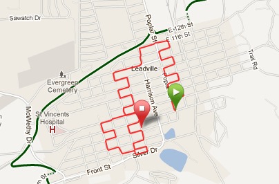
Not much to report today. I was able to scrub most of the black dye off my hands from yesterday using Gojo with two harsh scrub sessions. Then I went for an easy run around Leadville:
That was kind of a cool map to make, though with Leadville being on a hill, this was like a crazy interval run. Then I got a shower which thankfully took care of the rest of the dye on my hands. Otherwise? It's been a boring day. Matt and I had some lunch at a very good local Mexican place and have just done some housecleaning around the RV and watched Olympic coverage. Weather has been pretty rainy all afternoon, so not much else to be done.
So now that you're sufficiently bored, click this link and donate! Many thanks.
Not much to report today. I was able to scrub most of the black dye off my hands from yesterday using Gojo with two harsh scrub sessions. Then I went for an easy run around Leadville:
That was kind of a cool map to make, though with Leadville being on a hill, this was like a crazy interval run. Then I got a shower which thankfully took care of the rest of the dye on my hands. Otherwise? It's been a boring day. Matt and I had some lunch at a very good local Mexican place and have just done some housecleaning around the RV and watched Olympic coverage. Weather has been pretty rainy all afternoon, so not much else to be done.
So now that you're sufficiently bored, click this link and donate! Many thanks.
Wednesday, August 1, 2012
Never take two days off from Colorado adventure. Ever.
Because if you do, apparently Colorado tries to get you back for it in one shot.
The day started off innocently enough...I got up early, made my smoothie, got dressed for a three hour ride, and loaded up the motorcycle and headed over to Twin Lakes, the site of the 40 and 60 mile aid stations in the race. It's both, because when you leave you climb ten miles to the top of Columbine Mine, and then you turn around and do the course backwards from there.
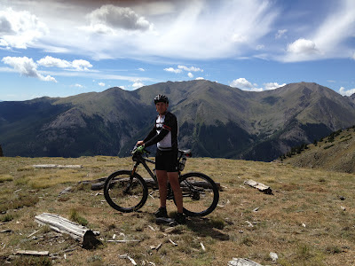
The ride was fairly uneventful. I'm happy with my performance capability, and learned a couple things. You can see the data here. I was even able to find someone to take a picture of me at the top:
So that was all good. Got back to the RV with a couple sprinkles on me on the way, got a shower, and Matt and I headed to Wild Bill's for some burgers and a shake. As we walked back, we could see the skies just didn't look good, and not long after sitting down, it started to rain. Matt was bummed because he really wanted to motorcycle ride, but I was kind of okay with it since I really just wanted to rest my legs.
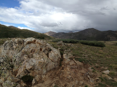
So we watched Olympics until about 3pm when it was no longer raining and Matt was itching to ride. The skies still didn't look great in pretty much any direction, but I went along anyway. Mistake, mistake, mistake. Matt wanted to go across Independence Pass to Aspen, so we headed that way. That takes you right by Twin Lakes, and I stopped briefly to consider riding to the top of Columbine just to show him the turnaround. But it was definitely raining on top of the mountain and not in the direction we were headed toward Aspen, so we went on. And Indpendence Pass was beautiful and amazing pavement up and over the Continental Divide. Here are a few pics from the overlook at the top:
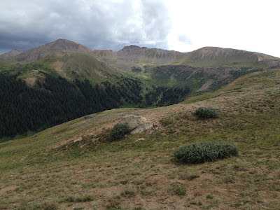
That's all from 12,095 feet, which is just above the tree line here. There were tons of people up there, all apparently from Aspen, because they were in shorts and t-shirts and were shivering. I'd guess it was about 50F there (which is way colder than it was at the top of Columbine Mine, which is 12,600 feet...strange). But I was wearing jeans, boots, t-shirt, and had my good Aerostich suit on over that, which has waterproof pants, waterproof shell, and a good thick fleece liner. So I was fine. In fact, I had the vents open on my coat while riding to cool off just a little.
Then we headed on into Aspen, where we found a cute little town with a lot of traffic. As we were stopped at a stoplight we decided neither of us was terribly hungry at that point, so we kept riding. It was about 5:15, so we had been riding two hours at this point. I had no idea what he was thinking in terms of how we'd continue on, I was just following him. We kept going through Aspen and out of town on highway 82, and he finally stopped about 15 miles out of town at a store. There he informed me we were headed toward Hagerman Pass to return.
Now, part of Hagerman Pass is part of the LT100 race course, and we had actually ridden from Leadville out Hagerman Pass a few miles just a few days ago before turning around because it was getting late. Everything we saw of Hagerman Pass was a nicely groomed gravel road, so that seemed fine to me. The weather was cloudy but didn't look threatening. So we headed on down through the town of Basalt, and out on Frying Pan Road. This road parallels a very pretty river that had fly fishermen everywhere. And it kept going and going and going. But I didn't mind...it was great riding. Few cars and lots of curves. Doesn't get much better than that!
We finally reached Ivanhoe Creek Road. That was what Frying Pan Road turned into when it turned to gravel. I had assumed we'd reach Hagerman Pass, not something else, but there was a "Utility Construction Ahead - Expect Heavy Delays" sign here. And there had been one of those on the other end of Hagerman Pass. So we figured this must be the right way. I wasn't worried about the construction, though, as it was after hours now.
We rode and rode and rode. This gravel road was fairly well groomed, but went downhill slowly the further we got until it was pretty much one lane with blind curves and some bumpy sections. It started to rain just a little and I signaled to Matt to pull over. We pulled over and used my GPS to make sure we were going the right way, and we were. But the rain was getting harder, and the sun was going away. And we had a long way to go. At this point, turning around would have meant a LONG ride on pavement back around. Probably a full 100 miles, in fact. And it looked like we were definitely less than 20 miles this direction. So we soldiered on.
And the road got worse. And the rain got worse. And the road got worse. And then it started to hail. And then we even got to a water crossing. Impossible to tell quite how deep, but there was a short spot to cross it that couldn't be too deep. My fear was that it would be a very soft bottom. So what do you do? Gun it. And it was fine. But at this point, it's getting cold, too. Very cold. And now the rain was so significant that every pothole was filled with water. And my gloves were not waterproof, and on this bike my seating position doesn't let my pants stay over my boots, so my feet were getting soaked, too. The rest of me was dry, thankfully.
But at low speed I couldn't close my visor because it would fog immediately. So I had to keep it open and just let the cold rain and occasional hail hit my face. It did act as enough of a visor to mostly keep it out of my eyes, at least. And now we were going vertical...straight up. Through rivers of water running down. Over huge loose rocks. With huge cliffs sometimes on both sides of this one lane road. And then we reached a sign...we were crossing the Continental Divide again. Duh, guess we had to if we had crossed it once on our way out. But then I noticed we were above tree line again. And there was occasional lightning, thunder, hail, and constant rain. And now we were going down. Through rivers. Through mudholes a foot deep. Over loose "baby heads" as trail folks call the big loose rocks. Around switchbacks. And back into the treeline.
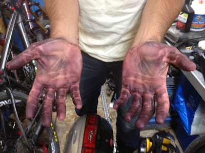
And that went on and on and on for what seemed like forever. And finally we reached the groomed gravel road on the other side. And soon pavement, and soon we were back in town. FIVE HOURS AFTER WE STARTED. Matt was more soaked than me as his gear isn't quite as rain-proof. But the worst part might be this:
The dye from my black leather motorcycle gloves seems to have at least semi-permanently stained my hands. I've tried soap and Gojo and they still look EXACTLY like that. This stuff is NOT coming off, period. It's quite horrible....I look like a coal miner!
I honestly and truly thought that the trip Matt and I took over Mosquito Pass was the most harrowing and crazy thing I might ever do on a street legal motorcycle. Boy was I wrong! This was like that, except with tons of water added. And my hands were basically numb the entire time. And you know, your hands are kind of important when you ride a motorcycle. But I have to say, my BMW G650X is one capable motorcycle. I might have been scared out of my gourd, but that bike just wouldn't slip or slide. It simply handled it and handled it well. I definitely learned I have much further limits than I thought when it comes to this kind of thing, but I would have been happy remaining ignorant to THOSE particular limits, let me tell you.
But I can't help but wonder how long my hands are going to be like this. sigh
The day started off innocently enough...I got up early, made my smoothie, got dressed for a three hour ride, and loaded up the motorcycle and headed over to Twin Lakes, the site of the 40 and 60 mile aid stations in the race. It's both, because when you leave you climb ten miles to the top of Columbine Mine, and then you turn around and do the course backwards from there.
The ride was fairly uneventful. I'm happy with my performance capability, and learned a couple things. You can see the data here. I was even able to find someone to take a picture of me at the top:
| Me at 12,600' at the top of Columbine Mine |
So that was all good. Got back to the RV with a couple sprinkles on me on the way, got a shower, and Matt and I headed to Wild Bill's for some burgers and a shake. As we walked back, we could see the skies just didn't look good, and not long after sitting down, it started to rain. Matt was bummed because he really wanted to motorcycle ride, but I was kind of okay with it since I really just wanted to rest my legs.
So we watched Olympics until about 3pm when it was no longer raining and Matt was itching to ride. The skies still didn't look great in pretty much any direction, but I went along anyway. Mistake, mistake, mistake. Matt wanted to go across Independence Pass to Aspen, so we headed that way. That takes you right by Twin Lakes, and I stopped briefly to consider riding to the top of Columbine just to show him the turnaround. But it was definitely raining on top of the mountain and not in the direction we were headed toward Aspen, so we went on. And Indpendence Pass was beautiful and amazing pavement up and over the Continental Divide. Here are a few pics from the overlook at the top:
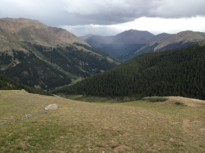
That's all from 12,095 feet, which is just above the tree line here. There were tons of people up there, all apparently from Aspen, because they were in shorts and t-shirts and were shivering. I'd guess it was about 50F there (which is way colder than it was at the top of Columbine Mine, which is 12,600 feet...strange). But I was wearing jeans, boots, t-shirt, and had my good Aerostich suit on over that, which has waterproof pants, waterproof shell, and a good thick fleece liner. So I was fine. In fact, I had the vents open on my coat while riding to cool off just a little.
Then we headed on into Aspen, where we found a cute little town with a lot of traffic. As we were stopped at a stoplight we decided neither of us was terribly hungry at that point, so we kept riding. It was about 5:15, so we had been riding two hours at this point. I had no idea what he was thinking in terms of how we'd continue on, I was just following him. We kept going through Aspen and out of town on highway 82, and he finally stopped about 15 miles out of town at a store. There he informed me we were headed toward Hagerman Pass to return.
Now, part of Hagerman Pass is part of the LT100 race course, and we had actually ridden from Leadville out Hagerman Pass a few miles just a few days ago before turning around because it was getting late. Everything we saw of Hagerman Pass was a nicely groomed gravel road, so that seemed fine to me. The weather was cloudy but didn't look threatening. So we headed on down through the town of Basalt, and out on Frying Pan Road. This road parallels a very pretty river that had fly fishermen everywhere. And it kept going and going and going. But I didn't mind...it was great riding. Few cars and lots of curves. Doesn't get much better than that!
We finally reached Ivanhoe Creek Road. That was what Frying Pan Road turned into when it turned to gravel. I had assumed we'd reach Hagerman Pass, not something else, but there was a "Utility Construction Ahead - Expect Heavy Delays" sign here. And there had been one of those on the other end of Hagerman Pass. So we figured this must be the right way. I wasn't worried about the construction, though, as it was after hours now.
We rode and rode and rode. This gravel road was fairly well groomed, but went downhill slowly the further we got until it was pretty much one lane with blind curves and some bumpy sections. It started to rain just a little and I signaled to Matt to pull over. We pulled over and used my GPS to make sure we were going the right way, and we were. But the rain was getting harder, and the sun was going away. And we had a long way to go. At this point, turning around would have meant a LONG ride on pavement back around. Probably a full 100 miles, in fact. And it looked like we were definitely less than 20 miles this direction. So we soldiered on.
And the road got worse. And the rain got worse. And the road got worse. And then it started to hail. And then we even got to a water crossing. Impossible to tell quite how deep, but there was a short spot to cross it that couldn't be too deep. My fear was that it would be a very soft bottom. So what do you do? Gun it. And it was fine. But at this point, it's getting cold, too. Very cold. And now the rain was so significant that every pothole was filled with water. And my gloves were not waterproof, and on this bike my seating position doesn't let my pants stay over my boots, so my feet were getting soaked, too. The rest of me was dry, thankfully.
But at low speed I couldn't close my visor because it would fog immediately. So I had to keep it open and just let the cold rain and occasional hail hit my face. It did act as enough of a visor to mostly keep it out of my eyes, at least. And now we were going vertical...straight up. Through rivers of water running down. Over huge loose rocks. With huge cliffs sometimes on both sides of this one lane road. And then we reached a sign...we were crossing the Continental Divide again. Duh, guess we had to if we had crossed it once on our way out. But then I noticed we were above tree line again. And there was occasional lightning, thunder, hail, and constant rain. And now we were going down. Through rivers. Through mudholes a foot deep. Over loose "baby heads" as trail folks call the big loose rocks. Around switchbacks. And back into the treeline.
And that went on and on and on for what seemed like forever. And finally we reached the groomed gravel road on the other side. And soon pavement, and soon we were back in town. FIVE HOURS AFTER WE STARTED. Matt was more soaked than me as his gear isn't quite as rain-proof. But the worst part might be this:
![]() |
| LOOK AT MY HANDS! |
The dye from my black leather motorcycle gloves seems to have at least semi-permanently stained my hands. I've tried soap and Gojo and they still look EXACTLY like that. This stuff is NOT coming off, period. It's quite horrible....I look like a coal miner!
I honestly and truly thought that the trip Matt and I took over Mosquito Pass was the most harrowing and crazy thing I might ever do on a street legal motorcycle. Boy was I wrong! This was like that, except with tons of water added. And my hands were basically numb the entire time. And you know, your hands are kind of important when you ride a motorcycle. But I have to say, my BMW G650X is one capable motorcycle. I might have been scared out of my gourd, but that bike just wouldn't slip or slide. It simply handled it and handled it well. I definitely learned I have much further limits than I thought when it comes to this kind of thing, but I would have been happy remaining ignorant to THOSE particular limits, let me tell you.
But I can't help but wonder how long my hands are going to be like this. sigh
Subscribe to:
Posts (Atom)